
Overview
Winter steelhead are sea-run rainbow trout. The Washington Department of Fish and Wildlife (WDFW) separates winter and summer runs by their seasonal movements. Winter fish spawn closer to the ocean. This page focuses on the rivers around Forks and the west side of the Olympic Peninsula. WDFW includes the Quillayute, Sol Duc, Hoh and Queets in its coastal steelhead management area.
Start with a river section, its rules and its access. Then choose a day. That order matters here. Olympic National Park has its own fishing rules, while tribal regulations need a separate check. A familiar river name does not settle which rules apply at your feet.
Hatchery fish and wild fish also need careful language. A National Oceanic and Atmospheric Administration (NOAA) review describes early-to-midwinter hatchery returns on the Peninsula. It also records overlap with natural-origin winter fish. There is no clean early-hatchery, late-wild split. Use the calendar below to frame your planning, then check the exact water before leaving home.
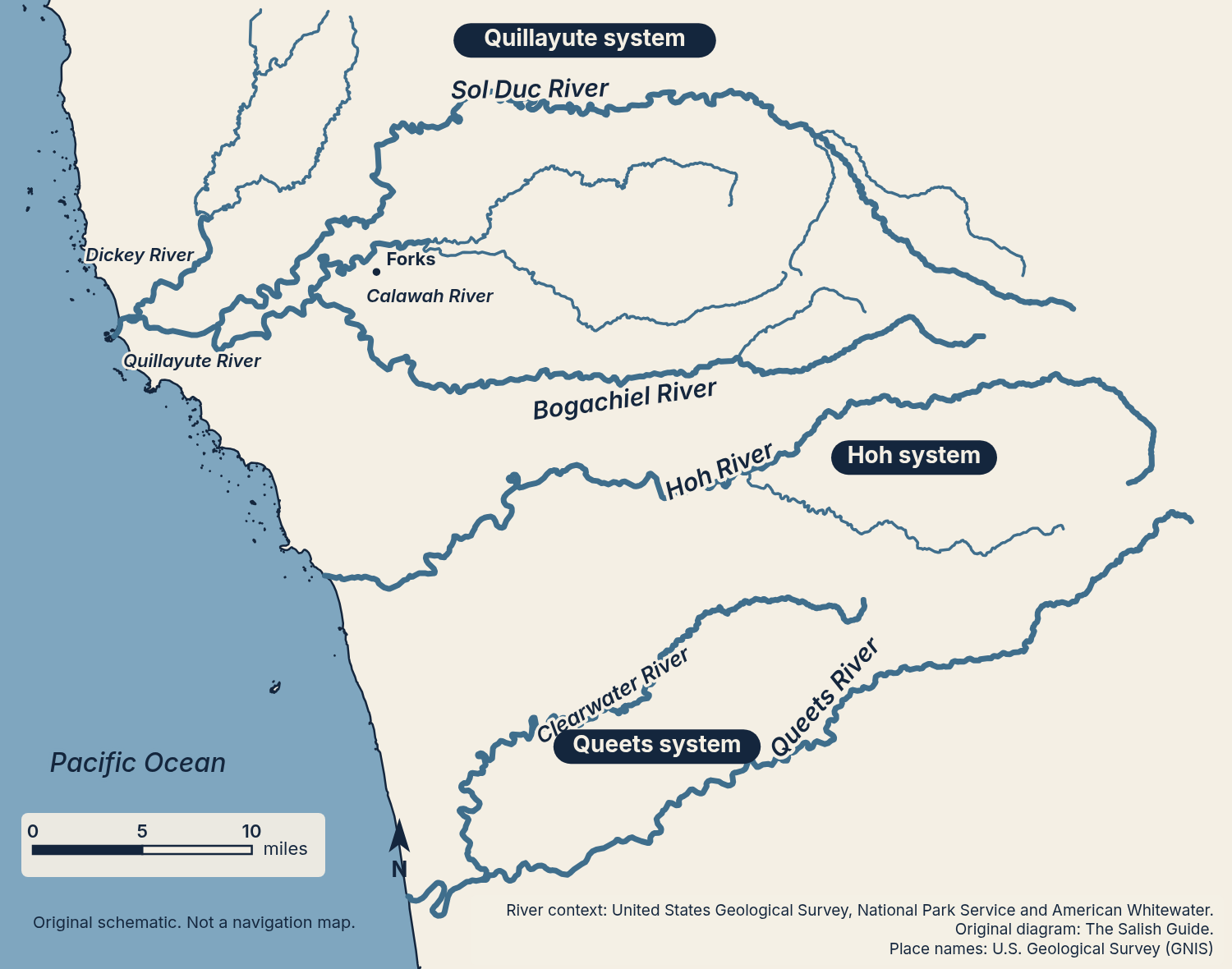
Schematic only. No access pins and no park boundary are drawn. Named forks are drawn without labels.
Best months: Dec–Mar — see December, January, February and March.
Getting There
From Seattle by Ferry
Two ferry approaches connect you with the north side of the Peninsula. The Seattle–Bainbridge crossing takes about 35 minutes. The Edmonds–Kingston crossing takes about 30 minutes. Those are crossing times, without the terminal wait or the drive to Forks.
From Bainbridge, the National Park Service routes you to US 101 by way of SR 305 and SR 104. It notes that the Hood Canal Bridge on SR 104 closes periodically for boat traffic. From Kingston, follow SR 104 west over the bridge. Continue to US 101 through Port Angeles, then follow US 101 past Lake Crescent to Forks. The Forks Chamber of Commerce describes the northern approach and the Lake Crescent leg. Washington State Department of Transportation (WSDOT) terminal directions confirm the Kingston connection to SR 104 and the Hood Canal Bridge. Check the ferry schedules while planning your departure.
Ferry-Free and Southern Approaches
The Forks Chamber describes a ferry-free route from Sea-Tac using I-5 south, SR 16 and SR 3. It then crosses the Hood Canal Bridge on SR 104 and joins US 101 through Port Angeles. The Chamber gives about 3.5 hours from Sea-Tac on a good day for the northern approach. Treat that as an approximate planning estimate.
The southern approach runs through Olympia and Aberdeen, then north along the coast. Choose your approach after checking the WSDOT Travel Center Map. Leave room in the plan for a later arrival. Avoid building a first river visit around the last bit of daylight.
The Hoh River Bridge Check
The US 101 Hoh River Bridge repair project can affect travel between Forks and destinations farther south. WSDOT explains that a bridge closure breaks the direct Forks–Kalaloch drive. The National Park Service says there is no alternative route or detour across the Hoh River. WSDOT routes travelers the long way around by Hood Canal and Aberdeen.
Read the Hoh River Bridge project page with the travel map before you choose lodging or a launch. Do not treat a repair notice from an earlier date as today’s road status. Check park road conditions for your final approach too.
Licenses, Passes and Permits
State Waters and State Access Areas
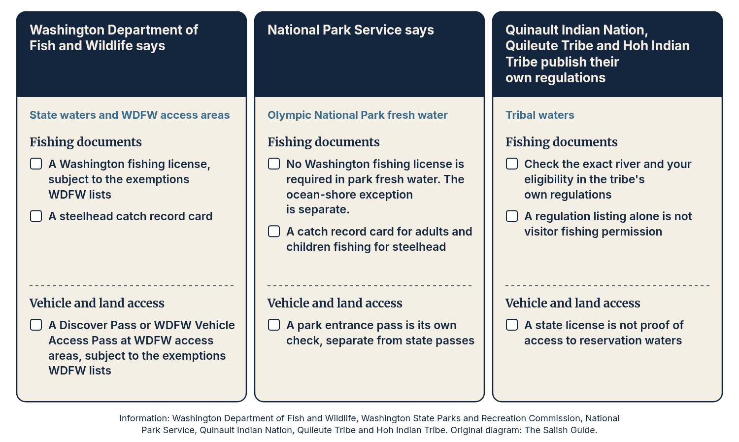
WDFW says Washington fishing licenses are required subject to its stated exemptions. It also requires a steelhead catch record card. Read the license page and catch record card instructions before the trip.
Vehicle access is a separate matter. WDFW says its access areas require a Discover Pass or WDFW Vehicle Access Pass, subject to the exemptions it lists. The Vehicle Access Pass covers WDFW lands only. The Discover Pass serves the broader state recreation-land program. Match the pass to the land manager rather than assuming your fishing license covers every parking place.
Olympic National Park Waters
The National Park Service says a Washington recreational fishing license is not required in Olympic National Park fresh water. Its ocean-shore exception is separate. Adults and children fishing for steelhead or salmon in the park still need a Washington catch record card. Read the park fishing page for the exact water and current requirements.
A park entrance pass is another separate check. It is not the same thing as a state fishing license or state vehicle pass. Keep the fishing documents and access documents together so you can review both before leaving the truck.
Tribal Waters
The Quinault Indian Nation publishes river-specific fishing regulations. Its visitor material describes fishing below Lake Quinault. Title 51 includes guided-fishing permit provisions. The code also addresses guests outside guided fishing. It does not support a blanket statement that every non-member must hire a guide. Use the Nation’s regulations index to begin the exact river and eligibility check.
The Quileute Tribe identifies the fishing regulations on its Natural Resources page as regulations for tribal members. The Hoh Indian Tribe lists winter hook-and-line regulations. Neither listing alone establishes visitor fishing permission. Do not use a state license as proof of access to reservation waters. Quileute visitor guidance also asks you to review its photography policies before recording on tribal land.
The Rivers
The section landmarks below help you find the right rule entry. They are not statements that a reach is open. Use WDFW’s current rules and emergency rules for state-managed water, then the park or tribal source where it applies.
Sol Duc
WDFW uses the Sol Duc Hatchery pump station and US 101 above Klahowya as section landmarks. The United States Department of Agriculture Forest Service places Klahowya Campground beside the river’s south shore. Keep these landmarks in your plan so you can match the water to the rule entry.
NOAA’s October 2024 review records the Sol Duc’s 2012 Wild Steelhead Gene Bank designation. It also records the end of winter smolt releases in 2013. That is historical management context, not proof that every fish now present is wild.
Gauge: we found no active United States Geological Survey (USGS) real-time gauge on the Sol Duc. The historical Soleduck stations 12041500 and 12042500 have daily discharge records ending September 29, 1980. Do not mistake those old records for today’s flow.
Bogachiel
WDFW names a mouth-to-US 101 bridge section on the Bogachiel. Its access inventory places Wilson and Rearing Pond on this river. American Whitewater independently identifies Wilson’s Bogachiel setting downstream of the Calawah confluence.
There is a documented hatchery context here. WDFW’s 2025 release table lists 107,637 winter-steelhead smolts. That release count is not an adult return forecast or a catch estimate.
Gauges: 12042800, Bogachiel River near Forks and 12043015, Bogachiel River near La Push. USGS reports water level only at the La Push station, rather than both level and discharge.
Calawah
WDFW lists the Calawah mainstem, North Fork and South Fork separately. Do not treat a mainstem rule lookup as a check of both forks. American Whitewater describes the Calawah joining the Bogachiel upstream of Wilson access.
WDFW’s 2025 stocking table lists 54,028 winter-steelhead smolts for the Calawah. Use that as evidence of a hatchery program in that release year. It does not establish permission to retain a fish now.
Gauge: 12043000, Calawah River near Forks. Open the station itself before deciding whether its information is fresh enough for your trip.
Quillayute
The Quillayute begins where the Sol Duc and Bogachiel meet. The Dickey joins farther downstream. WDFW’s river entry runs from the Olympic National Park boundary upstream to the Sol Duc–Bogachiel confluence. That boundary is part of the rule lookup.
NOAA’s historical review discusses both hatchery-targeted fisheries and natural-origin fish in the wider system. Do not turn that history into a claim that the lower river holds only one kind of steelhead.
Gauge: we found no active USGS station on the Quillayute mainstem. Bogachiel near La Push, 12043015, is a nearby tributary station with water-level data. It is not a direct measurement of the whole Quillayute.
Dickey
The Dickey is a Quillayute tributary. WDFW defines a section from the park boundary to the East and West Fork confluence. Use both ends when checking rules rather than searching only for the river name.
Gauge: we found no active USGS gauge on the Dickey.
Hoh
The Hoh starts high on Mount Olympus. Glacial sediment helps give it the slate-blue color described by the National Park Service. WDFW uses Morgans Crossing and the park boundary below the South Fork Hoh as section landmarks. Park water needs a separate park-rule check.
NOAA’s review discusses historical hatchery-targeted winter fishing in the Hoh system along with overlapping natural-origin returns. It does not provide a present-day hatchery-only window.
Gauge: 12041200, Hoh River at US Highway 101 near Forks. Read the station with the bridge travel check, but keep road status and river conditions as separate decisions.
Queets
Snow and glaciers on Mount Olympus feed the Queets. WDFW’s Queets entry directs readers to Olympic National Park for regulations. Begin with the park’s fishing page rather than borrowing rules from the nearby Clearwater.
NOAA includes the Queets in its historical discussion of hatchery-targeted winter fisheries and natural-origin overlap. The park names Queets Campground, Hartzell and Streator Crossing in its boating information. Winter storms can damage these facilities.
Gauge: 12040500, Queets River near Clearwater. Despite the station name, this gauge measures the Queets.
Clearwater
This is the Clearwater in Jefferson County, which meets the Queets upstream of the Queets gauge. It is not the same-named river in King and Pierce counties. WDFW identifies a mouth-to-Snahapish River section.
Gauge: we found no active USGS gauge on the Clearwater. The Queets station 12040500 lies 2.4 miles downstream of the Clearwater mouth. Its reading reflects the Queets rather than the Clearwater alone. We have not found a sourced Clearwater launch, so we do not list one.
Quinault
WDFW identifies an upper-river section from the upper end of Lake Quinault to the park boundary. Below the lake, the Quinault Indian Nation’s visitor information and fishing regulations are the starting points. Treat the upper and lower river as distinct planning tasks.
Gauge: 1203951610, Quinault River near Taholah. NOAA’s review supplies historical hatchery context for the system, not visitor eligibility or a current harvest promise.
Launches and Bank Access
A listed ramp is a facility description. It does not establish a safe float or a clear passage around wood. The National Park Service warns of logjam hazards on the Hoh and Queets. Scout your access and keep the decision to turn around open.
Quillayute-System Access Areas
These are WDFW sites. Their facility pages list amenities. WDFW’s access-site map data supplies the directions. Separate documents supply the river names where noted.
| Access | What the Sources Establish |
|---|---|
| Leyendecker | One concrete ramp. WDFW places it on the Bogachiel at the Sol Duc confluence. That river attribution has one originating agency. |
| Wilson | One concrete ramp on the Bogachiel. WDFW’s inventory and American Whitewater provide independent river evidence. |
| Rearing Pond | One concrete ramp and a fishing platform. WDFW places it on the Bogachiel. An American Whitewater listing supplies a second origin for the approach. |
| Thomas | Parking access with no ramp listed. WDFW’s historical inventory places it on the Bogachiel, a single-source river attribution. |
| Vannausdle | Walk-in access with no ramp. WDFW directs you south from Forks, then east on Dowan’s Road. A historical VanAusdale entry names the Bogachiel, but we have not confirmed the two spellings refer to the same site. |
| Maxfield | One concrete ramp. A Washington State Recreation and Conservation Office document places Maxfield Road access on the Sol Duc. That river attribution has one origin. |
| Salmon Hatchery | One concrete ramp and an accessible loading platform. WDFW’s historical inventory places the named site on the Sol Duc, a single-origin attribution. |
| Hillstrom | One concrete ramp. WDFW lists it near Forks and directs you north on US 101, then right on Hilstrom Road to its end. Its Sol Duc attribution rests on one American Whitewater listing. |
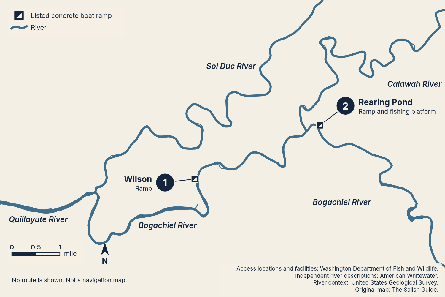
- Wilson: listed concrete boat ramp on the Bogachiel
- Rearing Pond: listed concrete boat ramp and fishing platform on the Bogachiel
Ramp symbols sit at the listed coordinates and numbered markers are offset with leaders. Leyendecker, Thomas, Vannausdle, Maxfield, Salmon Hatchery and Hillstrom stay in the page table and are not pinned because their river attribution has one origin or is qualified.
Parks and Forest Sites
The Washington State Parks and Recreation Commission lists Bogachiel State Park at 185983 Highway 101, Forks. Treat its park location as a park reference, not a verified boat-ramp coordinate. The Forest Service places Klahowya Campground on the Sol Duc’s south shore. Its campground listing does not establish a constructed launch or winter operation.
The Washington State Department of Natural Resources names Hoh Oxbow Campground and mentions boat-launch access in its recreation notices. It describes Cottonwood as a primitive campground near the Hoh. That description does not establish a constructed ramp at Cottonwood. Both river settings have a single agency source here.
The National Park Service names Hoh Campground and the park entrance-station vicinity as Hoh put-ins. For the Queets, it names Queets Campground and Hartzell Boat Launch. Its Queets brochure also names Streator Crossing. These access names share one originating publisher. Check current conditions before building a day around any of them. The Upper Queets approach uses Forest Service Road 21.
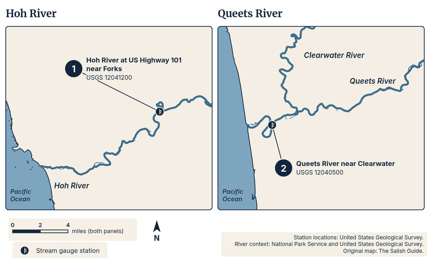
- Hoh River at US Highway 101 near Forks, USGS station 12041200
- Queets River near Clearwater, USGS station 12040500
Station symbols sit at the USGS site coordinates. No campground or launch symbols are drawn.
Named Spots
Wilson has independent river evidence from WDFW and American Whitewater. The latter places it downstream of the Calawah confluence. Rearing Pond has WDFW inventory evidence plus an American Whitewater listing for the hatchery approach.
The names above describe access, not guaranteed fish-holding water. Leyendecker, Thomas, Maxfield and Salmon Hatchery remain labeled with their single-origin river evidence in the access table. Hoh Oxbow, Cottonwood, Hartzell and Streator Crossing also remain single-source entries.
Clallam County’s parks plan describes foot access to Richwine Gravel Bar on the Quillayute. That is a single-source spot here, with no exact access coordinate established. It gets no map pin. Do not use the name to infer a public path across nearby land.
How Locals Fish It
We have not found a sourced account of which method local anglers favor on each river. We keep the method choices below as learning links rather than river-specific claims. Start with one approach and read its full lesson before deciding what to pack.
For bank fishing, use the lessons on drift fishing, float fishing and spoons and spinners. For boat-based planning, compare side-drifting with pulling plugs. Also see swung flies and plunking if those are the approaches you want to learn.
Choose a lesson to study, then check whether its gear and approach fit the current rules for your section. WDFW’s annual regulations and emergency rules are the state-water checks. The park publishes its own requirements. No method link on this page grants permission to use it.
Rules and Management
Rules change by river and in season. Check the current WDFW sport fishing regulations and emergency rules before every trip. Emergency rules update the annual rules.
For your exact reach, check fishing dates, retention rules and fish identification. Also check gear, bait and motor requirements. Use the named section boundaries rather than assuming one rule covers the full river. Repeat the check after choosing your access point.
WDFW’s coastal steelhead page explains the wider management picture. It describes declining survival and work with tribal co-managers on surveys, forecasts and plans. Its planning timeline says it will announce the 2026–27 steelhead season in December. As of November 2, 2026, WDFW had not posted a final winter fishing package.
WDFW also reports that NOAA found an Endangered Species Act listing unwarranted in 2026. That is WDFW’s summary of the federal finding. It does not remove the need for river-specific conservation measures. Keep the larger stock discussion separate from permission to fish on a given day.
Safety, Flows and Weather
Read the Station Before Reading the Number
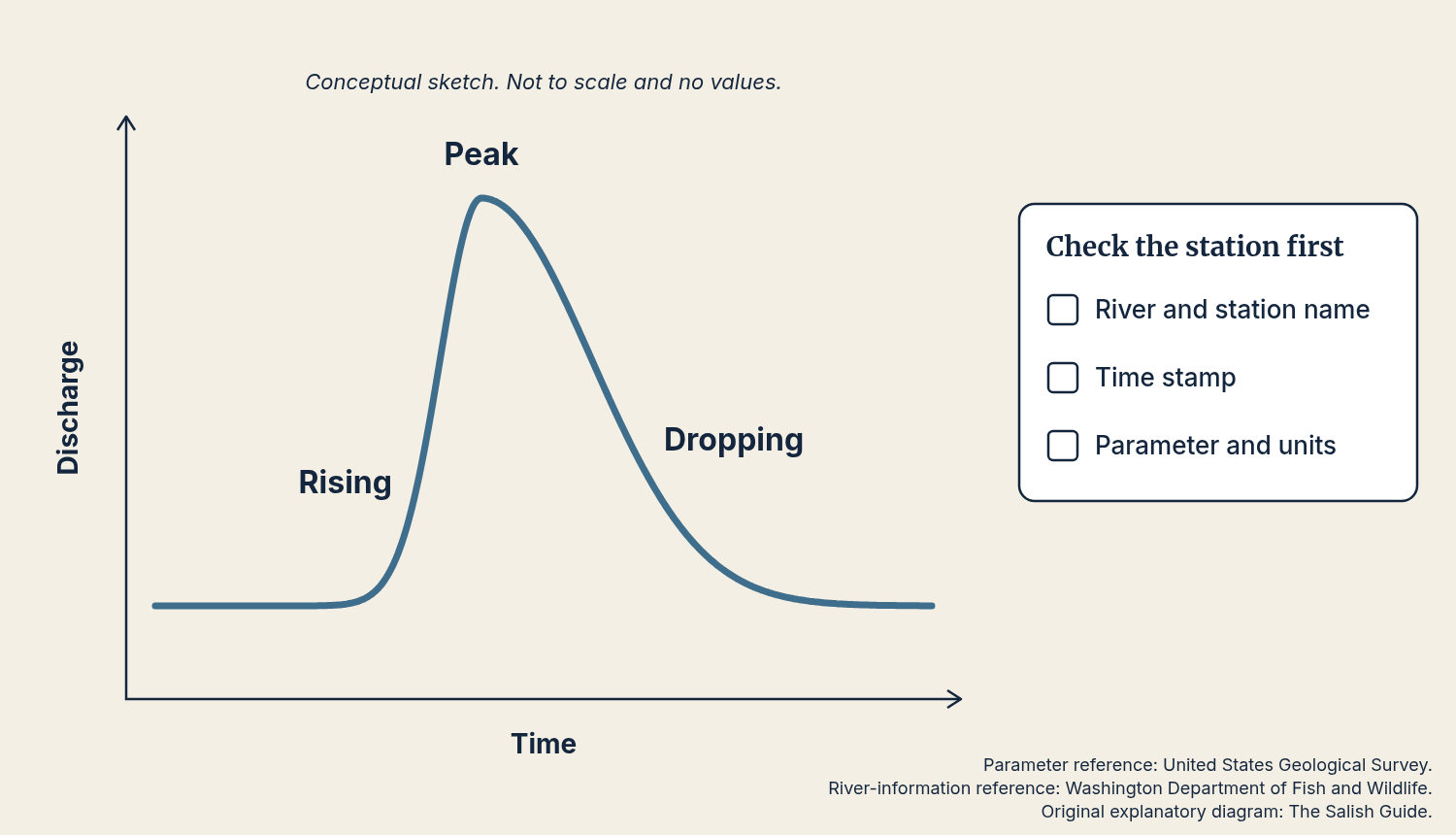
USGS stations identify both the river and the measuring site. Use the exact links in the river blocks. USGS reports discharge and water level at the Hoh, Calawah, Queets and Bogachiel-near-Forks stations. Bogachiel near La Push reports water level only.
USGS reports discharge in cubic feet per second and gage height in feet. Check the time stamp and the units before comparing readings. Compare a station with its own recent record rather than treating heights on separate rivers as equal.
Look at whether the line is rising, near a peak or dropping. That describes the recent trend, not a safety rating. We have not found a sourced safe wading number or safe boat-flow range for these rivers. WDFW’s north-coast survey page links river-level and forecast resources without supplying a universal threshold. Pair the screen check with a look at the actual water. Keep a bank-only alternative or a non-fishing day in your plan.
Wood, Crossings and Cold Water
The park warns of Hoh logjams and advises scouting ahead before paddling. Queets logjam hazards may occur throughout the year. Do not assume a previous trip or an access map establishes a clear channel today.
The park’s boating guidance warns that water temperatures stay below 50 degrees and that hypothermia is a risk. Bring a life jacket and dry clothing. Choose a plan that keeps you from needing a river crossing. The park says the Hoh and Quillayute cannot be forded at their ocean mouths. It also warns that the Queets crossing can be hazardous.
Rain and the Forecast
The National Weather Service places western Washington’s river-flooding season between October and April. Read the Seattle regional forecasts and warnings before departure and again before heading to the river.
For climate context, NOAA’s 1991–2020 normal at Quillayute State Airport is 101.32 inches of precipitation a year. November’s normal is 15.26 inches. Those are airport averages, not today’s forecast or a measurement for Forks town.
The National Park Service describes patchy cell service in most of the park and warns against relying on a phone for emergency help. Save your maps and rule pages in advance. Leave your destination and return plan with someone at home.
Seasonal Calendar
| Planning Period | WDFW General Timing | Broader Biological Context | Labeled Historical Example |
|---|---|---|---|
| November–January | Winter runs are distinct from summer runs. WDFW does not give a universal monthly Peninsula peak. | NOAA’s Peninsula review describes hatchery returns concentrated in early-to-midwinter, with natural-origin overlap. | December 2023: WDFW named early returning hatchery winter steelhead opportunities including the Bogachiel. This is one dated report. |
| February–April | WDFW’s winter-run description is general, without a separate late-wild calendar. | NOAA’s broad winter spawning-migration account extends through April. It is not an opening schedule. | No single-season example used. |
| May–June | WDFW gives no Peninsula-wide winter timing for these months. | The Peninsula review records some winter-run freshwater returns into June. That does not extend a fishing season. | No single-season example used. |
| July–October | WDFW describes summer steelhead as a distinct run. Do not carry the winter plan into these months. | No winter trip recommendation is made here. | No single-season example used. |

Months run July to June so each winter range reads as one unbroken bar. The lighter dashed bar is context and the December marker is one dated report.
First Trip Checklist
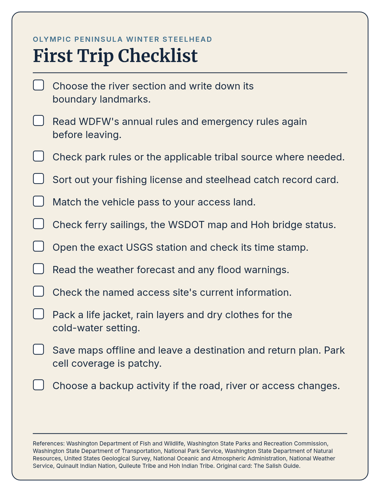
- Choose the river section and write down its boundary landmarks.
- Read WDFW’s annual rules and emergency rules again before leaving.
- Check park rules or the applicable tribal source where needed.
- Sort out your fishing license and steelhead catch record card.
- Match the vehicle pass to your access land.
- Check ferry sailings, the WSDOT map and Hoh bridge status.
- Open the exact USGS station and check its time stamp.
- Read the weather forecast and any flood warnings.
- Check the named access site’s current information.
- Pack a life jacket, rain layers and dry clothes for the cold-water setting.
- Save maps offline and leave a destination and return plan. Park cell coverage is patchy.
- Choose a backup activity if the road, river or access changes.
Tackle, Supplies and Lodging in Forks and Nearby
Tackle and Supplies
Forks Outfitters lists freshwater and fly tackle along with rods, reels, boots and waders. The Forks Chamber lists fishing licenses and sporting goods at 950 South Forks Avenue, Forks. Use the business’s own page for the goods description. Confirm any item you need before building the trip around buying it on arrival.
Lodging
The Forks Chamber lists Forks Motel, motel accommodation at 351 South Forks Avenue, Forks. It lists Pacific Inn Motel at 352 South Forks Avenue, Forks. The Chamber lodging directory provides a wider starting list.
Choose lodging after checking which side of the Hoh River Bridge your day requires. A closure changes the direct north–south road connection. Keep arrival, access scouting and fishing as separate parts of your plan. Give yourself room to change the last one.
Methods
Use these as short routes to the full lessons:
Guides Who Specialize in This
Find Olympic Peninsula steelhead guides
Ask your guide for their WDFW guide license number before you book.
FAQ
When Should I Plan a Winter Steelhead Trip?
Begin with the winter-run context, then check the river’s actual rules. NOAA gives November–April as a broad spawning-migration period. Its Peninsula review records a wider return range and overlapping hatchery and natural-origin fish. Neither is a season announcement. WDFW’s planning page says the 2026–27 announcement is due in December.
Does a Washington License Cover Every River Section?
No single document settles the whole trip. WDFW licenses, park fishing requirements and tribal regulations need separate checks. The National Park Service says a state license is not required in park fresh water, but adults and children fishing for steelhead need a catch record card. Check where you will stand and fish.
Which Gauge Should I Use for the Sol Duc?
We found no active USGS real-time gauge on the Sol Duc. Historical stations 12041500 and 12042500 have daily discharge catalogs ending in 1980. Do not relabel a nearby river’s reading as the Sol Duc’s flow.
Is Every Named Access a Boat Launch?
No. WDFW lists Thomas as parking access without a ramp and Vannausdle as walk-in access. Campground descriptions also need care. Cottonwood is described as a primitive campground near the Hoh, without proof of a constructed ramp.
Can I Drive Around a Hoh River Bridge Closure Nearby?
The National Park Service says there is no alternative route or detour across the Hoh River. WSDOT routes travelers the long way around by Hood Canal and Aberdeen when the bridge is closed. Check the project page and travel map before choosing your route.
Related
- Olympic Peninsula Region
- Steelhead
- Winter Fishing
- WDFW Coastal Steelhead Management
- Olympic National Park Fishing
Sources for this guide are listed on our Credits page.
— The Salish Guide